Planned night cross country flight route: PAFA-PAML-PACL-PAFA [skyvector.com graphic]. Ended up doing PAFA-PAML-PANN-PAFA (PANN is in the compass circle near image center) so CFI3 was very sure we’d avoid the restricted area west of PACL.Ground winds 0kts all day at both destinations. Skies clear. I tried really hard not to get my hopes up because I kept remembering how fast Alaskan weather could change.
Went to the flight school early to do everything as perfectly as possible. As soon as the night winds aloft were posted, I did my wind correction angle calculations; finished the compass heading, groundspeed, time, and fuel calculations. I had prepared weight&balance numbers for the 150 but it’s still down for its 100hr inspection/diagnostic of a hard starting problem. Had to redo my stuff for the 152 last minute because I’d forgotten which plane I was flying.
CFI4’s car broke down as he was driving to the flight school. I was getting ready to go home and continue my long string of waiting, but CFI3 came back from another student’s night flight and agreed to go with me. Cool!
Pre-snow on the ground, the CFIs took care of all fueling – aw isn’t that nice. But now that it’s cold, I’ve noticed them making students fuel more. I have only fueled the plane ~twice so I’m still not completely confident in my ability to correctly complete all steps. In fact…I was filling the left wing in the 152 but didn’t know to look into the tank to know when to stop (I’ve always only been told to hold the handle down for ‘X# of seconds’ because we’ve never needed a full tank). Wasted about half a gallon of 100LL on the tarmac, gah!
Our 152 doesn’t have a GPS, but does have ipad foreflight. It was having problems turning on in the cold – definitely something I should have taken care of before starting the plane and rolling out to the run-up area. I’m now convinced to have an extra charged warm ipad available when flying the 152 – I mean, what is one to do if the first ipad dies? There’s no other in-plane GPS available. Charts are okay in daylight but pilotage is impossible at night… Tonight, CFI3 had his own charged unit as a backup.
CFI3 had me open my flight plan in the run-up area instead of waiting til I was in the air (as I had done for the day xc). I like this better because it was less workload later.
Flying to Manley (PAML) was uneventful except for the fact that I kept drifting off heading. I also let myself be distracted by CFI3 teaching me to use foreflight. He kept asking for information I knew was on my written flight plan – but was more easily/quickly available on foreflight (if one knows where to look! Which I didn’t….). Foggles on, although they didn’t really make a difference in my vision – route had absolutely no lights anywhere. Moon wasn’t up yet and there was no aurora. Lovely darkness. I was surprised that I never felt any disorientation in the air tonight (even though I couldn’t see anything but the instruments and that darn sloped dashboard).
It took me longer than I liked to set up a good stabilized approach for landing at PAML. Runway was intruedarkness – unlike at PAFA. No PAPI (this was a first). Much harder than my previous night landings. CFI3 had to help with the moderate crosswinds down to pattern altitude. Landing itself was fine but I freaked CFI3 out when I went to do the ‘go’ part of what I thought was a touch-and-go. There are mountains at the end of my runway – I had misunderstood his earlier instruction to taxi to the end and turn around. Trying to quickly correct my mistake, I forgot that you do not use the wheel brakes on an icy runway. Supposed to do aerodynamic braking by pulling back on the yoke. Minor sliding, exasperated CFI3 who was disappointed I didn’t already have all the basic winter flying tips in mind. Sorry!
In our short time on the ground, we were visible on the airport weather cams (we were monitored from the flight school), neat 🙂
Takeoff good, focus went immediately to the attitude indicator when airborne, as it should have been. Foggles on. CFI3 turned off my ipad and told me to divert to Nenana (PANN) instead of flying to Clear (PACL). I had the correct VOR frequency ready to go from my flight plan notes, but then I messed the steps up. First, I put the VOR frequency in the COM radio instead of NAV. Then I forgot how to tell if you were receiving the station (hear morse code/TWEB broadcast) and how to tell which radial you are on (just center the needle!). Ugg at myself! I knew this stuff. I’ve done it before. I wasn’t expecting to need VOR knowledge tonight (PAML and PACL don’t have VORs), but that is no excuse.
Light turbulence was minorly distracting.
Position report/update flight plan with FSS: I’d written an RCO frequency on my flight plan but it was wrong. Darn it. Then my mind blanked on how to find an usable frequency on the sectional. It’s in a large box Christina, sheesh….
Overshot my intended altitude by 1200ft because distracted by VOR stuff. Problems maintaining correct heading continued, kept ending up 400ft high (slightly ‘off’ trim settings on my part). I’d forgotten to look up this leg’s cruise tachometer vs altitude settings from the 152’s POH, which was just embarrassing.
PANN landing: pretty nice. Used wheel brakes again (ah, what is wrong with me?). Takeoff fine but I didn’t focus on the attitude indicator as immediately after takeoff as I should have.
Mumbled a little when contacting Fairbanks Approach. Ooops.
PAFA landing: straight in final. Started too low, then went way too high, then was way too fast (80kts, oops), then too low, ah! But actual touchdown surprisingly good, straight & centered.
My GPS groundtrack is pretty lousy – not straight lines between destinations. Man…
SPOT personal GPS track of my night xc flight
We returned 45 minutes later than my initial calculations. We used 6 more gallons of fuel than I’d calculated (not insignificant!). Fortunately, we still had an extra hour of fuel left (even though we were late). CFI3 pointed out that my flight plan had not included any taxiing/stopping time for any of the airports. D’oh. My planned trip with CFI4 had no extended stops, no stop and goes – unlike what I did tonight with CFI3. I should have built in taxi time anyways and I take full responsibility for that mistake (but I choose to be in a pretty bad mood because of it. I hate being wrong).
Overall, I’m not too impressed with my performance tonight. CFI3 has got to just think I’m an idiot.
—~—~—~—~—~—~—~—~—~—~—~—~—~—~—~—~—~—
Things to work on:
Study the terrain more before xc flights. I knew the general features, but CFI3 asked for specific peak terrain heights – which I had to search for. I should have known these.
Leaning the mixture: I still don’t see the minor rise in RPMs I’m looking for…
Landing: take the initiative in using flaps instead of waiting for CFI prompting.
Visualizing the correct runway shape when landing without a glide slope indicator: my night hours are now done so I will only get to practice this in daytime.
Bring a headlamp to all flights. Dual night hours could still happen if I schedule flights ‘late’ in the day. In the 150, we’ve only used the red dome light. Tonight, both CFI3 and I had red headlamps on. It was nice to get light wherever I looked.
Taxiing: I think I’m centered but I’m really too far to the left.
Taxiing: slooow down [when there’s ice].
I’ve finally figured out how to use a radio system with more than one radio. The 150 only has 1 so I’ve never had to deal with selecting transmit 1/2, phone 1/2. The 152’s speaker option is disconnected – simplifies my options even more. Since only fly the 152 if absolutely necessary, it will be a challenge to retain this new knowledge.
—~—~—~—~—~—~—~—~—~—~—~—~—~—~—~—~—~—
On the leg to PAML, CFI3 asked if I realized how close I probably came to dying on Saturday’s flight. Dark question. I said maybe and asked him to explain: Firstly, icing could have been a lot worse. ‘It was a stupid decision to fly through a cloud in winter in a plane without de-icing capabilities (moisture + freezing temperatures = bad)’. Mistake: not constantly asking for updated weather throughout the flight (ex. the freezing rain at Galena shouldn’t have been a surprise we discovered at PAUN FBO). Flying through the clouds on the way back to PAFA: risked icing again with no good (close) diversion airports on the remote west coast; should have overnighted in Unalakleet.
“Want to visit western Alaska and the Pacific Ocean?” YES. Anywhere really, I’d be fine. I haven’t been in a small aircraft in 3 weeks and I’m getting antsy. Riding as a passenger with a fellow flight school pal is fun. He wanted to fly to Unalakleet (PAUN) – it was a rare day there with completely calm winds, clear forecasted weather.
It all started out so well.
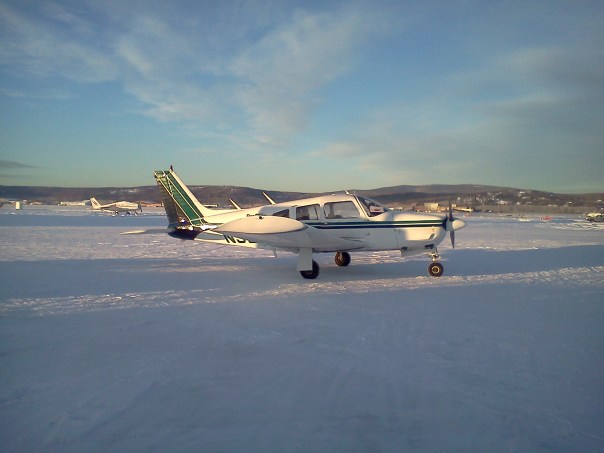
The brave plane, the flight school’s Piper Arrow
Then we saw this as we looked towards the threshold of runway 2R at PAFA (Fairbanks).
Oh, this is a great omen to see at the end of your runway. Was a firefighting exercise – but doesn’t it just look awful?Here we go! (icy windshield, runway is so clean!)
Maneuvering on course, I pick out my favorite Fairbanks landmark:
University of Alaska Fairbanks – the only place I can positively identify from the air
Route: PAFA-PAUN [skyvector.com graphic]Near Minto Lake
Our route passed the villages/towns Tanana, Ruby, Galena. After Tanana, our forecasted clear skies disappeared.
Great looking distant clouds near Ruby, AK. Makes me think of English moors.Sun pokes out near Ruby or Galena; can’t remember which. Completely a tease because the clouds quickly rolled back in.
We got an IFR clearance through the clouds for ‘VFR on top’ [of the clouds], 12,000ft. Flying through the cloud was fun – my pilot found a makeshift ‘tunnel’ where the above clouds were blueish (sky) so even though we were ensconced in a cloud, we could still see both ground and sky from our position. Outrageous several thousand feet thick cloud.
Looking through a cloud.12,000ft – my new small aircraft passenger status accomplishmentCool clouds. We’re getting close to Unalakleet!Yukon River, west coast AlaskaFluffyFluffierRainbow orb over the wing. Much brighter in real life. There’s got to be an official name for this. Anyone know it?
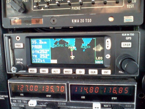
Anchorage Center ATC told us to descend to 5000ft – it put us just inside the clouds – my first time being in the cockpit going level through solid clouds. Such a way better view than from a commercial passenger seat. Pilot noted a sudden buildup of ice crystals on the windshield. Looked like snow that wouldn’t blow away. Nothing very visible on the wings. I noted the GPS was now displaying the words “Pacific Ocean” and it hit me that I was really going to see the Pacific Ocean (exciting for me because I grew up in Georgia/lived next the Atlantic Ocean (Daytona Beach). Woohoo, visiting a new beach!). I looked away from the wings to quickly snap this picture:
GPS: next stop: Pacific Ocean?!? Awesome!!!
In that moment of looking away from the wings, wing icing became visibly noticeable. I’m still surprised at how quickly that seemed to happen. Call up Anchorage Center; were cleared block 5500-6000ft, VFR on top. This put us just over the clouds, back into sunshine! Outside temperatures -5°C, no real ice sublimation but at least there was no new ice accumulation. The Arrow has no wing de-icing capabilities. Descend back into the clouds to land. We used RNAV-A approach for Runway 8. Pilot remarked that CFI1 had once told him never to use PAUN runway 15 with IFR unless necessary because that IFR approach is over mountains – we’re definitely not trying that with such low visibility.
PAUN instrument approach procedure for runway 8: RNAV (GPS)-A. What is the circular track for? I should ask someone.
This approach is cool because it requires you to go out over the Pacific ocean quite a way! I’d never seen sea ice before. The ice patterns were simply spectacular, strikingly alien; lonely.
Pacific Ocean out past Unalakleet. These ice patterns are so strange!!!!!! Why are there things that look like the edge of a stamp/square wave?Pacific Ocean out past Unalakleet. These ice patterns are so strange!!!!!! Why does it look like the edge of a stamp?Pacific Ocean out past Unalakleet. These ice patterns are awesome.Pacific Ocean near Unalakleet – looking north.Pacific Ocean near Unalakleet – looking north. This landmass looks like it comes out of nowhereStrange road looking line across the ocean.More cool Pacific Ocean ice
Sometime over the ocean, the pilot self announced that he was changing to runway 15. I’m not sure why he did this other than the fact that he thought coming in to land parallel to the coast was super cool. Even though he initially asked to use approach aids to runway 8, I think runway 15 was his plan all along.
Unalakleet runway 15 right next to the frozen ocean. The village is in the distance.
Landed and went onto the ramp. VFR flight plan closed. Started looking for fuel building. No cell phone service. That surprised me – I understood why we had no signal past Nenana but I figured an established village would have this modern convenience. No response from the FBOs on the radio. When we were east of Unalakleet, a passing pilot/FBO (I can’t remember which) had said 100LL was available in ‘the blue building. Go inside and ask for the key’. Easy peasy. Except….there were about 5 widely spread out blue buildings, no real signs of human activity.
We finally saw people walking into this building and took a chance. I think my pilot recognized the green plane out front from one of those Alaskan reality tv shows.
Welcome to Unalakleet. Wait, which Alaskan reality show was building on? Fly Alaska? Is there more than one Alaska flying show? (Naturally my pilot knew…but I forgot what he said)
Went inside and got directions to the fuel place. Apparently the FBO lady was someone my pilot recognized from reality tv. Cool, I met someone famous today 😀
The fuel building:
Where’s the fuel? Taxi around for a bit and finally made it here. This was called the ‘blue’ building. Uh, really???
Got out of the plane; the pilot inspected the propeller ice as I looked at the wing ice.
Wing icing – uh oh.Ice on the wing formed the most interesting delicate feathery pattern – but not soft. I couldn’t crush it down with my hands.
I played around with trying to scrape off the wing ice, but it wasn’t going anywhere. Pilot called me over to look at the propeller ice. From the tone of voice, it sounded bad. Do I even want to know?
Propeller blade icing. Ahhh no!Good grief that’s a lot of ice on the propeller.
Asked the fuel attendant if there was a hangar we would borrow for an hour to melt the ice? No. Uh oh. Fueled up and the pilot went inside to call the flight school. I couldn’t contribute anything, so I took pictures outside near the FBO.
Cemetery – at the edge of the airport.Pacific OceanPacific Ocean – View from Unalakleet airport
Went inside to get the updated news. The flight school was handling calls to people they knew in Unalakleet for borrowing hangar space. They were also calling people to see if we could spend the night with someone in town, if necessary. Pilot lamented the fact that his wife would be upset he had gone on such a long flight without telling her (and especially since he would now be really late for dinner).
Pilot went outside to turn off the navigation lights (a master switch accidentally left on will quickly drain a battery in the cold weather) and cover the plane with its engine blanket [My pilot got all his private and instrument certificates in the Fairbanks summer, he didn’t get all the CFI plane instructions about winter flying].
It turns out that the FBO could arrange for the plane to be sprayed down with de-icing fluid. The attendant rolled out a 2 foot canister (keg like thing). We were thinking we’d get a de-icing truck, oh well 🙂 . Once sprayed, the ice could easily be knocked off. I never realized that de-icing fluid was bright red (it never looks red when my commercial flights were sprayed) – different compound?
De-iced plane, $100 later. Red de-icer makes it look mortally wounded. Hurray – won’t have to overnight in the village!
FBO personnel told us we didn’t need to pay anything for the de-icing. Turns out they eventually billed the flight school $100 for the 20 minute job and the bit of fluid used. Not that I’m complaining because they really saved us, but wow, $100. There really isn’t anything cheap in aviation.
Internet reported weather along our return route wasn’t pretty. We were so remote that the only east diversion airports for a long distance were Galena, Ruby, Tanana. Weather improved as one goes east, but would be pretty terrible for a long time. Galena was even reporting freezing rain. Ahh!
My pilot hitched a ride to the local store to pick up AAA batteries for our SPOT personal GPS tracker. The flight school makes all xc rentals carry it so they can watch our progress. They told the pilot to replace the batteries before we left PAUN. I though it was just a safety precaution (‘use fresh batteries, just in case’). The green lights on SPOT were still blinking away. I didn’t find out ’til after we landed in Fairbanks, but our SPOT batteries had died as we hit the low cloud layers earlier in the day. On the school’s google map track, our path started deviating from the straight line path (probably lots of turns as we tried to find a cloudless path) and then the signal cut out. This explains why I got hugs when we returned to Fairbanks – they thought we had gone down in the plane!
I wish I had gone to the store too (I’ve never seen a village store). Oh well, stayed warm at the FBO, eavesdropped on the passengers waiting for their delayed flight to Anchorage. Quaint little terminal area they have there, complete with uncomfy airport seats. Several quite unhappy people who had wanted more time with family (hey now, we all hate flight delays, but one doesn’t have to get snippy with the desk agent). I couldn’t figure out why the family wasn’t waiting with the passengers at the FBO. It’s not like TSA was stopping them from being in the terminal.
Being Asian, I look like I could pass for an Alaskan Native. I got the feeling that people in the corner were talking about me arriving as a passenger in a fancy private plane with a white male pilot, but I couldn’t make out any specifics. I don’t know if I really want to know. On the bright side, if I do an xc to a [relatively] remote village one day, I’ve been told that being able to pass for a native could be very useful (many villages aren’t receptive to ‘outsiders’).
The thought ‘Yes, we drive to work in Alaska’ comes to mind. I was wearing my giant parka this day – I couldn’t imagine riding around on an 4-wheeler. The higher humidity from the ocean made me so cold! (Fairbanks is really dry). Of course though, the village is really small, commute times short…
4 AAA batteries cost $7, say what?!? I’m carrying spare batteries on all future flights. And extra cash. I suppose this cost is par for the course when you don’t have roads connecting you to any supply routes. On Adak Island (out on the Alaskan Aleutian island chain), a gallon of bottled water is $15, expired chocolate baking chips (the only chocolate on the island) sold for $7 [my friend really had to satisfy his craving].
Unalakleet as we flew away. Weather deteriorated *fast*!
Conditions at takeoff were overcast 4000, still VFR. No incoming PAUN pilot had picked up ice like we did. Pilot pulled an IFR map out of his bag, handed it to me, and we quickly got going. His primary navigation was ipad foreflight – but the ipad had been in the cold plane so long that it was reluctant to charge/start – kept turning itself off. We circled over the Pacific until the ipad finally started working. Meanwhile, my pilot quickly realized the clouds were lower then reported.We continued circling as the pilot called for a pop up IFR clearance. It was getting late so Anchorage Center was consolidating all regions to a few controllers (I think it eventually went to 1 controller for the entire state near the end of our flight). Had to wait for quite a while for a controller to get to us.
Western Alaskan weather was entirely IFR. All pilots in the area (lots at nearby Nome, AK) were waiting on the ground, calling for clearances. My pilot was kicking himself for not taking care of it on the ground. We continued to circle and I was asked to help remember numbers/instructions (as the pilot was too busy flying to write anything down). Unalakleet doesn’t have radar coverage so we couldn’t get cleared direct to Fairbanks. Talked for a while about different options. Were asked if we could handle our own navigation over the terrain until we entered the radar area – the strained ‘no’ from my pilot had me a little worried. Visibility was dropping pretty fast. Eventually settled on flying at 4000ft on some VOR radial, would get cleared Fairbanks direct later.
We eventually came out just over the clouds – just missed sunset but glad to be out of the clouds. Were cleared Fairbanks direct at 7500ft. Pilot noted something in the plane was drawing large amounts of current. Turned off 1 of the plane’s 2 moving map GPS units and the ipad, things improved. Autopilot engaged. Ipad only intermittently turned on to doubly verify we stayed on the victor airway.
Light misty clouds. No visible ice on the wings. As we passed Galena, AK, we noted that the vertical speed indicator (VSI) and altitude indicator needles started deflecting wildly (in phase) in all directions. VSI was the worst – indicating 1000ft/min up, then sudden drop to 1000ft/min down, then oscillations continued. Airspeed indicator dropped to 40 knots (GPS and foreflight confirmed groundspeed was still ~130kts, altitude 7500ft). Obviously, the speed, VSI, and altitude instruments were wrong. Reconfirm pitot heat was on. Use headlamp to check for wing icing: icing negative.
Pilot called Anchorage Center to report the loss of flight instruments (as is required when flying IFR). They asked if we were declaring an emergency. No. I think my pilot asked if we could have another altitude (to see if icing would change?). The only option presented was lower – no thanks because it was completely dark outside. 7500 is way more than enough to clear any terrain we’d come near, and that’s what we stayed at. Pilot went up 400ft high and had Anchorage Center read our radar altitude to us until we got back to 7500 – crosschecked foreflight altitude and it was accurate. Throughout the flight, ATC would periodically read us our radar altitude and groundspeed – they matched our GPS readings all night. The plane’s autopilot worked beautifully and we had no abnormal deviations.
I’m so not looking forward to following a Victor airway on my checkride (in the 150) without autopilot.
Pilot then remembered the Arrow had a secondary static source. It lagged a lot, but it mostly fixed the altitude and VSI indicators (still had temporary periods of rapid swings). Celebrate with snacks from our emergency supplies bag.
I’ve half-halfheartedly tried to memorize the following chart for a while (instrument effects of blocked pitot/static sources), but haven’t been getting anywhere. I’m much more committed to doing this now.
Pitot/static system blockage indications chart from my Jeppesen course
Pilot mentioned at one point that he’d felt we were in a 30° bank for a long time (although the attitude indicator had always displayed that we were completely level). So strange because I was also looking at the instruments (and that annoying ‘leans’ catalyst, the sloped dashboard), but I felt perfectly level. I guess the ‘turning’ feeling is a function of how much is on your mind. Pilot warned me that the leans have never gone away in all his IFR [training and personal flight] hours – but one does get used to it.
Periodic [exercise style] headlamp checks out the windows verified no wing ice. Periodic use of the landing light showed that we flew through a bit of snow & light clouds. Moving at 130 kts through falling snow makes things look so much cooler then at the relatively low maximum car speeds, something like the example below, but better 😉
Moderate turbulence started up as we passed Tanana. Figures that it would; another stressor for the remainder of this flight.
Skies completely clear as we came within ~100 miles of Fairbanks. Pilot started counting down the seconds ’til arrival. Airspeed indicator came back for a bit I think. Anchorage Center gave my pilot a phone number to call when we landed – to make sure we had landed safely. A small part of my pilot was afraid it was also for a reprimand. I’m a completely inexperienced pilot, but I couldn’t see that happening – we did everything they told us to…
I managed to find the Nenana (PANA) airport beacon in the distance (good practice for my upcoming night xc flight to the town a couple of miles south, Clear, AK (PACL)). Minor temporary VSI and altitude quick up/down fluctuations, but overall, things were looking good as we started our descent to Fairbanks.
All of a sudden, the airspeed indicator went to zero. Oh crap.
Fairbanks. Starting the descent. Picture taken just before the airspeed indicator went to zero knots. Ah shoot. Morbid thoughts: ‘Made it through so much today, figures that this is how it ends.’
I think tower told my pilot to do a landing ‘by the numbers’? Was it because our airspeed was high? I should ask someone. Pilot responded that we had just lost our airspeed indicator and that he was landing with as high an airspeed as possible so we could be sure we wouldn’t stall. It took me a moment to remember the GPS’s indicated groundspeed is not necessarily the same as airspeed.
Came in low but landed safely, a greaser for sure. Took a bit longer than usual to slow enough to turn off the runway. Turned off at taxiway sierra; kept rolling while asking for clearance to taxiway charlie. Someone really wanted out of that plane! (not that I disagreed with him). Interesting note: tower said turnoff sierra onto charlie was always uncontrolled. Really? Now I’m confused. I’ll still never head onto any part of charlie without clearance, I’m not gutsy enough for that.
As we tied the plane down, we noted the pitot tube looked like this:
Pitot icing seen after we landed. Hey pitot heat, why didn’t you help us?
So strange to have this amazingly smooth large layer of ice. Flight school personnel said they were expecting to see something really rough. The wings were completely clean, no ice. CFI3 suggested that this ice was probably caused by pitot heat; he meant insufficient pitot heat right? Heat melted frozen precipitation/water vapor, air temperature allowed ice to form. Insufficient heat then would have done nothing to get rid of ice. I need to think about this physics of this a bit more. We’ll see what the mechanic says about the pitot heat system inspection next week. I think the pilot mentioned that from now on, he’d do a pitot check touch-and-go in potentially icing conditions – I need to remember to ask him to clarify this procedure/theory.
Pilot called CFI2; boss man chastised pilot for flying through low level stratus clouds and picking up ice. Pilot mentioned something about Fairbanks having tons of low level stratus during the winter – how is an IFR flight to avoid low-level stratus in that case? I need to ask CFI2 to clarify.
Pilot called Anchorage Center – they wanted to use our flight recordings as a future training tool. Interesting. Praise to him from an ATC supervisor included statements that many ‘more experienced pilots have never had so many flight demands in one flight’, and those ‘experienced’ pilots probably wouldn’t have handled themselves so well. I’m interested to see what my pilot put down in his logbook.
—~—~—~—~—~—~—~—~—~—~—~—~—~—~—~—~—~—
This seven hour flight (exclude waiting around time) was quite the experience. My first IFR cockpit ordeal. I’m sure the pilot was completely stressed inside (he kept lamenting ‘how could *so many* things go wrong on *one* trip?!?’), but was outwardly so professional, calm, and confident, I was never very worried at all (or too inexperienced at flying to really know how bad it really was). I even took several unintentional naps on the trip (sorry Dave – it’s a compliment, I trust you. You’re going to be a great commercial pilot next month).
It was a great confidence building trip; saw all these crazy stressful situations occur and how they’re all completely manageable & survivable. – Feeling confident in my flight school’s instructors. Train me! 😀
Long waiting game detailed here. Only of interest if you want to hear about bad Alaskan weather. Actual flight described in next post, Night Cross Country Flight.
—~—~—~—~—~—~—~—~—~—~—~—~—~—~—~—~—~—
Wednesday, Nov. 6: So mad. Crystal clear skies over interior Alaska. That evening’s auroras covered the entire sky for most of the evening [first time I had seen all sky coverage] and were perfectly timed to coincide with my last required night flight hours (!), but the beacon light fixture on the 150 broke and the ELT antenna on the 152 broke (limiting the plane to 50 nautical miles) – leaving me with no rent-able aircraft.
UAF’s Poker Flat Research Range – Neal Davis Science Operations Center [credit artist of http://www.flickr.com/photos/musubk/]The UAF physics students ended up at the Poker Flat Research Range to watch the aurora. It was fantastic – but I couldn’t quite stop thinking about how I had missed a special opportunity to fly relative to the auroral curtain motions (it isn’t usually visible so early [green lights started ~830pm – near the end of my planned 2.5 hour night cross country (xc)] and if it is, it doesn’t usually continue all night – which in this case, it did). In the past, students who fly on aurora nights have been able to talk the instructor into extending the flight plan so they could enjoy the aurora away from city lights (I mean, you’re already in the middle of nowhere, might as well enjoy it). I’ve been told the aurora flying experience is spectacular….now I’ll have to wait til I get my private pilot certificate (or hope the sun is active for my next commercial flight). 😦
I’m definitely still mad at the beacon light situation. Turning it on during preflight had been tricky for about a month now; we kept reporting it on the aircraft logs; just figured it was slow due to the cold temperatures (~20’s °F). On Wednesday, CFI4 reached up to tap on it (try and get it to turn on); it fell off. [How is he freakishly tall enough to not need a ladder?!? 😉 ] I always feel bad about hounding the school over ‘minor’ problems like a light being slow to turn on – especially since every little fix always takes days longer than expected….and that’s time the plane isn’t profitable for the school….but forget that from now on. I don’t want a similar preventable delay to occur in the future.
Night cross country flight: PAFA-PAML-PACL-PAFA [skyvector.com graphic]CFI4 had complimented me on my navigation log; after my flight was canceled, he kept teasing me about being ready to give me my solo cross country endorsement at the end of the night if we had flown…ahh (evilness 😉 )!
I’m really rather proud of what I presented for inspection (although I do admit that I hastily put it together ~2 hours before I went to the flight school – ‘my best work is usually done under pressure’??? excuses…). Everything was extra legible, already had all my weather, AF/D runway info, all heading corrections; ground speeds, fuel, and weights&balances calculated, flight plan ready to go, extra notes written in the margins about differences between day and night flying, no mistakes* (with my expectation that I would check all current NOTAMs (Notices to Airmen) just before takeoff). It amazed me that some students had shown up for past cross country flights without the basic prep work (and more than once!). They take so long to write up nicely; showing up without the prep work leads to paying for the instructor to watch you sit in front of the computer on the ground, eating up your entire flight block. My only minor slip-up was that I forgot to bring a parka and snowpants to my flight (ugg, I can’t ever move in all those layers). It was only ~+15°F in Fairbanks (you don’t need snowpants until ~ -27°F, they’re too hot), but I still got the ‘mom’ lecture about how one always needs extra precautions when flying in the winter.
*My school has current Airport Facilities/Directories (A/FD) but gives copies of expired A/FDs to students to use in xc planning (Alaska doesn’t usually change that much – but one destination, Manley [Hot Springs], is an exception – airport was constructed this summer). Current NOTAMS say the summer runway 2-20 (only 1 runway listed in my AF/D) is closed permanently, is now a taxiway; a new runway, 18-36, is now in use. I didn’t know this until my instructor checked the online NOTAMS while I rechecked weather – a good lesson to me to always be through (and recheck everything when using expired publications).
—~—~—~—~—~—~—~—~—~—~—~—~—~—~—~—~—~—
I’ve been rescheduling for basically every night since Wed., Nov. 6. To save me money on my training, I wasn’t ‘supposed’ to do any more flying until I do the night cross country.
Thursday: 150 had last minute beacon electrical problems, 152’s ELT still broken. Cancel.
Weekend: Heavy snow and fog all over interior Alaska.
Monday Nov 11: overcast morning but clear & sunny all afternoon! The 150 had potential engine problems (the engine stopped as a student touched down on the runway during touch-and-goes. We’re not convinced that it wasn’t a carburetor icing/lack of carburetor heat problem…). I’d fixed the 152’s ELT antenna on Sun. Nov 10, so that plane was ready to go. However…..the afternoon’s unexpected sunlight created a fog layer over the runway. So strange, no fog in town/over airport, just a thick layer over the runway (beneath crystal clear skies). The touchdown point was clear but the rest of the runway was covered. This was confirmed by the instrument rated pilot who flies at my flight school. Lucky for him that he had the knowledge to do an ILS (instrument landing system) approach. There was zero wind so the fog wasn’t going anywhere all night. Fog wasn’t forecasted to grow….but CFI2 and CFI4 said not to take any chances – Fairbanks has plenty of winter nighttime left for me to fly in – some other day. Their instincts were right: Fairbanks clouds & visibility dropped right at the time I was scheduled to land back at PAFA.
Tuesday: CFI4’s long day at his ‘real’ job flying military helicopters – he could fly with me, but would he be tired? Plus, my ‘real’ job’s weekly research meeting is on Tuesdays (and they are thoroughly exhausting). No flying.
Wednesday – Thursday: Heavy snow and freezing rain (got half a centimeter of ice frozen to my car – underneath 6 inches of snow, ahhh!). Winds 35kts gusting to 40s&50s. Weather bad enough to warrant a rare Fairbanks occasion: classes canceled due to winter weather. Trees took out many people’s electricity for several days. Flight canceled.
Friday: I was feeling lazy and didn’t schedule anything (naturally, PAFA weather looked lovely). I wasn’t sure if my destination runways were graveled/sanded/plowed after the interior Alaska freezing rain episode (even the main Fairbanks roads were still a bit iffy), so it was probably fine to wait.
Saturday: All day, clouds too low for comfort (2100ft) near one of my destinations (PACL’s nearest weather is Nenana ASOS). Flight canceled and 2 hours later, the skies turned perfectly clear. Darn it.
Sunday: clear at destinations, snow/fog at PAFA
Monday Nov 18: snowing – went night cross country skiing instead of night cross country flying.
Tuesday: Clear weather but lack of insulating clouds means it has finally gotten too cold (FAI in the -20’s °F) to fly the 150 (coldest allowed by flight school: -15°F on the ground, 0°F at altitude). The 152 rental limits are -20°F on the ground, 0°F at altitude. I had 6 hours of afternoon meetings on top of 3 hours of sleep, so I didn’t schedule a flight.
Wednesday and Thursday: It’s soooo cold! -20s to -30somethings °F. Too cold to fly anything but the Arrow (which is good down to -30°F on the ground, 0°F at altitude). Plus, it was weather class nights 1 and 2.
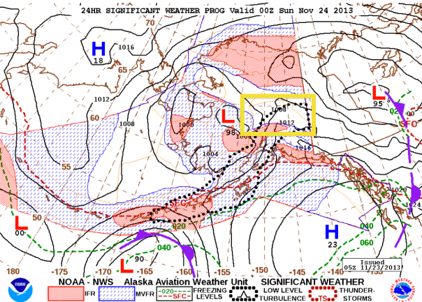
Friday: clear and warm (~+15 even at night) because of the Chinook wind from the south. Looking at this week’s temperature records, it’s completely wild! CFI2 uncomfortable with a night xc for me: clouds at minimum allowable height for night VFR at PACL. Forecast at the Alaska Aviation weather site was interesting: had the Tanana Valley clear but every other forecast zone was MVFR or IFR. Forgot to save that image, but it looked something like this:
Tanana Valley (encloses Fairbanks and my destinations Manley and Clear) boxed in yellow. For most of the afternoon, every forecast zone (orange thin lined shapes) in Alaska was MVFR and IFR except for Tanana Valley. Almost impossible to believe? MVFR boundaries form a pointy boundary? Aii….
Did night cross country skiing underneath the aurora instead.
It’s been almost 3 weeks since I was last able to fly – and I’m definitely convinced to get my instrument rating so I have more flying day options. Also, safety! (read about my first unexpected IFR ride-along) The example I mentioned above, where you could have a VFR afternoon and return to the Fairbanks airport to find just the runway covered with low fog (but not the town), makes me uneasy.
My flight school is owned by a CFI who is a weather guru with many years as a military aviation meteorologist. He requires all students in the flight school to take his aviation weather class. Tonight was class #2 of 2.
This class was much more fun than yesterday. CFI2 provided anecdotes from his days as a weather forcaster – I would have really enjoyed a session of just anecdotes. The best one: while writing a forecast after staying up all night, he wrote something like: ‘it’s clear, may become few, scattered, broken, or overcast; chance of rain, fog, or snow, […].’ – I forget the exact words but it was cleverly written so no matter what the weather did, he wouldn’t be required by regulations to issue any amendments during his work day. Cue major yelling from the base commander in the middle of nap time. Sigh, I’m not surprised CFI2 would do that 😉 such a character.
My most important class take-aways (stuff I didn’t already know):
Weather prediction centers: they issue 2 forecasts – one for the general public (tv news, radio, internet, etc), one for pilots. Each is handled by a separate person. Because the general public forecast is seen by so many people, there is more pressure not to screw up; a very experienced forecaster does this one. A rookie forecaster handles aviation weather. I guess I shouldn’t be surprised when aviation weather reports are inaccurate.
When CFI2 was weather forecasting in the midwest USA, he once saw a severe thunderstorm extend above the normal tropopause (!). He went to issue a weather warning, but was told by a supervisor not to because only ~10 people lived in the area to be hit. When weather warnings are issued, there must be a follow-up where any damage must be accounted for. Because the area was so sparsely populated, no damage would be expected. After the storm passed, this was verified – no damage reported. This makes me wonder about weather reporting in Alaska. Over 30,000 people live in Fairbanks, sure, but when I fly somewhere like Manley (pop. 100), do I need to worry about warnings not being put out? I’m supposing forecasters here err on the side of caution (many warnings) because aviation is the only ‘road’ to so many communities.
The importance of the area forecast discussion – I always ignored this but it is important to know how much the forecast models may have diverged before the final products were issued.
Alaska weather changes ridiculously rapidly: ex1. Outrageous rain on a 40 minute flight (ie Fairbanks to Fort Yukon), refuel, completely clear skies on the leg back. ex2. Summer Fairbanks thunderstorms (what few we get) can take about 10 minutes to move out of the way. Intentional minor delays can pay off huge in safety.
Rule of thumb: horizontal visibility of 1/2 miles generally means vertical visibility of 500 ft.
Why W0X0F is significant to CFI2 – and why it’s prominently displayed on his car, hahaaaa, funny. W0X0F is weather code for ‘indefinite ceiling, zero visibility, zero due to fog’.
Weather phenomena code FFG – stands for freezing fog. No need to freak out as a pilot, it doesn’t mean the fog is sticking to your plane as ice – it just means the [ground] air temperature is below 0°C (ice particle fog).
You can call and talk to forecasters to have them clarify their predictions (example from a canceled flight of mine: ‘you didn’t predict fog until 9pm, I’m seeing fog at 3pm; why is this and is it going to lift any time soon?’).
Commercial pilots have been known to call the weather predictors to get them to revise their forecasts to better meet current conditions and weather trends (to allow for commercial flights when the original forecasts unnecessarily grounded them per FARs – remember aviation forecasters are usually more inexperienced). [I think this statement I read somewhere sums it up nicely: ‘Lucklily(?), the FAA doesn’t care if you kill yourself {in bad weather}, but they really freak out if you kill someone else’]
Radar products are only really accurate up to a 80nm radius (and data holes can exist when heavy precipitation is close to the radar)
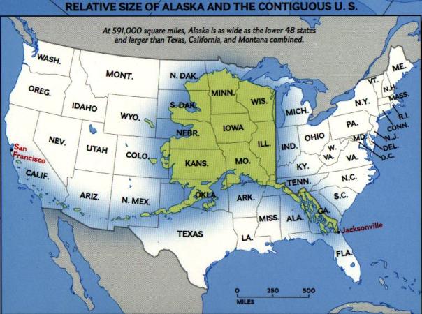
Radar coverage in Alaska is soooooo bad!!!!!! Oh the radars work fine, but for a state which is larger than Texas, Montana, and California combined, there are only 7 radars, only 1 in the interior of the state (see maps below).
Alaska is huge!Compare the number of weather radars in the lower 48 with that of Alaska. Shocking! Fairbanks is the AK ‘+’ site in the middle of the state. Data doesn’t exists for the darker browns&blues. Almost everywhere I fly in Alaska is dark brown. Reminds me to take AK weather products with a grain of salt. [http://www.wunderground.com/radar/map.asp]
—~—~—~—~—~—~—~—~—~—~—~—~—~—~—~—~—~—
Overall, I think the time and money for the class was worth it; most of it (~90%?) I already learned from the Jeppesen online course (basic theory) and poking around the flight school’s weather briefing links/AAWU, but repetition is the best way to get the knowledge ingrained in one’s head, so it is okay. Even CFI2, with his decades of practical weather experience, still learns new weather knowledge all the time (even with all the science available, forecasting is still more of an art). Plus, the break time ginger cookies were made with real, fresh ginger: awesome! 😀
My flight school is owned by a CFI who is a weather guru with many years as a military aviation meteorologist. He requires all students in the flight school to take his aviation weather class. Tonight was class #1 of 2.
Tonight we covered weather formation theory: what happens to heated air, conditions for stability, adiabatic heating and cooling, temperature lapse rates, effects of the solar insolation, layers of the atmosphere, moisture changes of state, cloud formation & types, atmospheric circulation, details of how highs and lows affect weather movement, Coriolis effects, and all kinds of fog.
My favorite part was radiosondes/dropsondes and the data interpretation slides. Brings me back to the days of my bachelor’s degree capstone project. I built a UV based ozone detector designed to fly on a weather balloon. We released 3 balloons that year, refined the process/equipment along the way (see page 5 of http://daytonabeach.erau.edu/coas/physical-sciences/news-events/newsletters/EP_Newsletter_Spring_2009.pdf. Yes, we put a satellite on top of our Christmas tree). Anyways, radiosonde data: it’s really cool how much you can tell about the atmosphere from humidity vs temperature/altitude plots.
Temperature inversion slides were made much more interesting by the fact Fairbanks is currently sitting in such a layer. It was slightly lower than -30F all day but if you go up the in-town ski slope, temperatures were reported at +40F. The inversion layer’s height has been visible all day via smoke/condensate:
The flat layer tops were still visible from the airport tonight. A lot of Fairbanks residents still use wood stoves in town which makes for fantastic visuals, hundreds (thousands?) of smoke trails as you look out over town.
Something really cool from my geophysical fluid dynamics class today: you can calculate the vertical temperature gradient (departure from the adiabatic gradient) if you know the wind speed and wavelengths of the perturbation of the temperature interface.
class notes
Waves at today’s Fairbanks temperature inversion boundary [Courtesy B. Wu]I may update this post with actual calculated numbers (on Friday after I verify I did the math correctly).
—~—~—~—~—~—~—~—~—~—~—~—~—~—~—~—~—~—
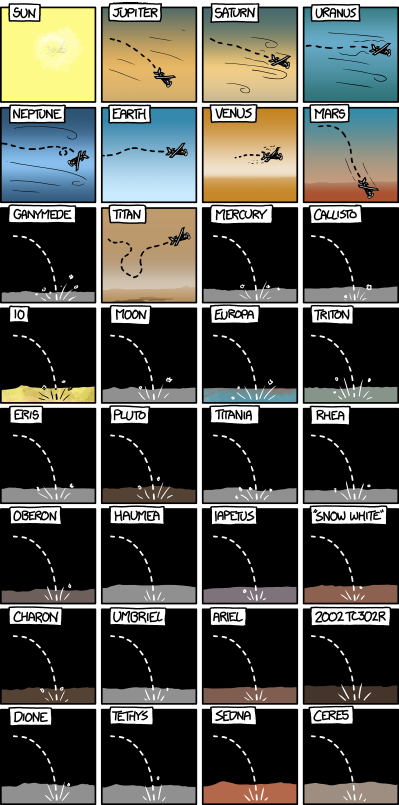
Random cool thing I found: Interplanetary Cessna 172!
What would happen if you tried to fly a normal Earth airplane above different Solar System bodies?
Here’s what happens when an aircraft is launched above the surface of the 32 largest Solar System bodies:
Here’s what happens when an aircraft is launched above the surface of the 32 largest Solar System bodies. [http://what-if.xkcd.com/30/]
While I’ve not had time to personally validate all their claims, the statements look legit. More detailed explanations available on their page, http://what-if.xkcd.com/30/
—~—~—~—~—~—~—~—~—~—~—~—~—~—~—~—~—~—
If you’ve wondered why there haven’t been any posts in forever – it is because I haven’t been able to fly since Nov. 4. Lots of little reasons why (mostly weather related). It’s all documented with some great aurora photos; will be posted when I next get to fly.
Yesterday’s ‘soft’ field landings were a bit miserable so CFI4 wanted me to do some pattern work today (2R, right base). It was a nice day for it because I was alone in the pattern and winds were calm.
Cessna 150 – let’s go have some fun 🙂
We did 3 normal landings and I dropped CFI4 off by the fuel pumps. I was feeling really confident because my landings were really stable, straight down the centerline, no ballooning. My turns to final needed work (was both early and late), but I was sure I could fix this by the end of the day.
I was rolling along on the ramp when ground asked me to ‘give way to a small cargo plane exiting at sierra’. Oh shoot, ‘where was runway turnoff sierra?’ I really need to study the PAFA airport diagram more. Fortunately, I knew where the cargo buildings were so I could hang out just short of them.
During my first solo, I noticed that I was a bit of a lighting rod for ‘out of the ordinary’ radio instructions. The streak continues. Even more ‘unusual-ness’ in a moment.
Today I definitely noticed how quickly the plane lifted off the runway without the instructor weight. It was also sadly quiet, no one to have a conversation with, aw. First 2 laps in the pattern were just like my supervised ones, I turned final too early but landed nice and smooth.
Pattern 3: on upwind, I noticed a new thin column of black smoke rising from somewhere across town. As I reached 500ftAGL, tower asked if I saw the smoke. Oh yes, the column had grown noticeably taller and wider. Tower asked if I would go and fly circles around the smoke and try to determine its exact location and cause.
North Pole cement plant fire [http://www.newsminer.com]It’s human nature to be curious and a bit nosy – I really wanted to say yes, but let’s face it, I still get lost sometimes when I drive around Fairbanks (poor spatial awareness, oops)…and I’m still having that trouble recognizing runways against terrain. It would be a terrible idea to send me anywhere away from the airport.
I just gave tower a “no, 4-romeo-echo”. I think that surprised the controller because he asked again, explaining that it was really close and that’d he be able to clear me to land quickly when I returned to the airport (uh, was there another option to keep me in the air all day? Fairbanks International isn’t exactly busy on a Monday morning). I replied that ‘I would rather not’. ATC was persistent and asked me a third time to check things out. This routine was really flustering – I finally told him I was a student pilot practicing solo landings. Was finally cleared for the option but I had been distracted to the point where I was 200ft above pattern altitude. Darn it. Touched down a bit nose flat, slightly sideways. Arrr. After this, tower started calling all my crosswind, downwind, and base turn in the pattern for the rest of my flight (ugg, patronizing! I do know those flying basics! Ironically, he said nothing about turns to final – and I never fixed those problems today). Deep breaths.
Tower had asked an inbound small plane to divert and take a look at the now billowing black smoke (again promising a quick landing when he got back to airport). Pilot reported the fire location near Badger Road (at North Pole, a town 30 minutes [by car] south of Fairbanks), that fire trucks were on the scene [http://www.newsminer.com/news/local_news/fire-destroys-building-at-north-pole-cement-plant/article_736d621e-4597-11e3-bcbc-0019bb30f31a.html], and that he was already heading back to the airport. I had just taken off again and tower told me that I was cleared for a left crosswind turn.
Um, say again, what? Runway 2R does all right turns….I had to confirm with him twice that he was asking me to fly left over the parallel runway and airport. Maybe I’m really glad that liveatc.net doesn’t currently archive tower recordings because I know my voice went up a couple of octaves during this ‘conversation.’ It’s times like these that I really wish my flight school had an extra radio for me to carry in the plane for solo pattern work. I would have enjoyed the expertise and firm hand of someone who knew what they were doing. Well, CFI4 and CFI2 were both listening to everything on the handheld unit, and I suppose if I were really in trouble, they could just use that to talk to me (small hand held units are the only plane radios for some of the bush pilots delivering cargo to Alaskan villages….if it’s good enough for them…. [they always sound ridiculously static-y and I’m surprised anyone can hear anything they say)].
Got to fly all the way over commercial terminal (and the parallel runway that huge jets use, eek!). I had no idea where to fly my downwind leg though. Over the runway seemed like a terrible idea, so I set up on a regular left base downwind on 2L. We were all waiting for the above mentioned “spotter plane” to land on 2R – he would get to land before me. The thought: ‘What the heck do I do once I get abeam the end of 2R’ popped into my head….Silence on the airwaves so I started my normal descent, carburetor heat, throttle back (no flaps). I extended downwind a bit and was cleared to turn base. Oh thank goodness (silence makes me nervous).
I’d been working on nailing the turn to final all day, so I was really proud that I rolled out nicely lined up, PAPIs only slightly low. Then I noticed the ALSF below me (High Intensity Approach Lighting System With Sequenced Flashing Lights). Crap. Oh no, oh no, oh no. I was lined up on the wrong runway (2L). I was cleared for 2R which had no fancy lights. Begin long diagonal path to 2R. Nothing from tower about my gaff and thankfully I realized my mistake high enough above the ground.
For the non-pilots in the crowd, an ALSF in action is seen at 0:11 in this youtube video:
Picture of ALSF (to a pilot, the white ball of light will move towards the runway) [http://www.flyplatinum.com/blog/?p=492]It was another non-straight landing, nose flat, but I told myself I had an excuse. Almost landing on the wrong runway really freaked me out. ‘Let me try it one more time’ I thought.
This one was way off to the left of center and I couldn’t keep the wings level. Got it stable just before flare, but it was nose flat, slightly crooked, and I definitely scared myself. Another deep breath and I impulsively pushed full throttle again. I just needed to relax and I’d be fine….right? No, one more flat, uncentered, crooked landing, and I was done for the day. Tired of tower calling all the turns that I know; tired of missing centerline when I had done it fine just an hour ago, tired of not touching down straight, tired of landing nose flat when I know better! I’m so disappointed in myself.
I’m not sure how many of my ugly landings CFI4 and CFI2 watched from the flight school, but I take comfort in the fact that CFI2 told me I handled tower’s ‘unusual’ requests just as I should have. Small comfort.
Judging time in Fairbanks winter afternoons is tricky. This is 2pm – I thought it was ~430pm.
Flight block at 8:30am – so early!!! It’s not a big secret I enjoy waking up ~2pm. But with daylight savings today, Fairbanks sunrise is at 8:40am & sunset at 4:20pm this week; daylight still getting shorter. I need to get used to morning flights because there won’t be time to fly in my afternoons.
I was extra tired because I procrastinated on my ground school homework. Woke up slightly cranky but who could stay grumpy when one gets to fly a plane?
—~—~—~—~—~—~—~—~—~—~—~—~—~—~—~—~—~—
Last lesson (Friday), CFI2 told CFI4 that I was to do my first cross country flight today (Sunday) – sounded awesome to me before I realized that meant I had to read 3 huge sections in the Jeppesen online ground school (‘aircraft performance’, ‘navigation’, and ‘flying cross country’). I thought I’d have plenty of time. Out of the blue, I got a text message from the school at 5pm on Saturday (they track student progress online and had noticed I hadn’t done anything, oops). I had run into delays all day in changing the all-season tires on my car to snow tires. I have two sets of rims, one for winter, one for summer – so it is a fairly straight-forward process: jack up the car, loosen some lugnuts, swap tires. However, you remember from my last post that Fairbanks now has snow all over the ground… I spent all morning waiting for the people who store my tires to wake up and unlock the storage closet (no tires are allowed in the dormitory where I live) – then I had to wait for my friend with a garage (snow free floors, yay) to wake up. Tire change took me 2 hours because I’m an automobile inexperienced girly-girl sometimes (but I managed it without any help!). Ugg, it was 6pm, where did my day go?
I was considering canceling my flight, but being a huge asian stereotype, I stubbornly refused to let a mountain of homework hold me back. 10 hours of work later, I had scratched the surface of: reading all types of performance charts in POHs, mechanical flight computers, computing plane weight and balance, VOR navigation, pilotage & dead reckoning, GPS, navigation, ADF navigation. My head was swimming, and I really wished I had completed a ground school before actually starting to fly. There’s no way I learned everything in the lessons, will need to go through it all again.
—~—~—~—~—~—~—~—~—~—~—~—~—~—~—~—~—~—
Skyvector.com graphic: PAFA-PANN-51Z-PAFA
CFI4 picked our cross country route: Fairbanks (PAFA), Nenana (PANN), Minto (51Z), Fairbanks. First we worked through the steps of filling out a VFR navigation log. The calculations using a mechanical flight computer seem so foreign right now, but I have to admit, it was really cool to be able to do all the heading corrections and speed, enroute time, and fuel burn calculations with just a metal sliding circle. [BTW fellow pilots, do I really need to buy my own?]
In filing my first flight plan with the local Flight Service Station (FSS), we discovered that my Georgia area code cell phone won’t connect to any FSS via the normal 1-800 number because I’m on Alaskan cell towers. At least the local number is fine.
Preflight: when lowering the final 10° of flaps on the 150, the gear mechanism made the plane shudder. CFI4 said it was just because the plane was cold (this will probably continue to happen all winter). I didn’t notice anything when using flaps in the air.
PAFA taxiway lines had been partially scraped clean of snow, but it was really impressive to see the entire run-up area completely dry and snow-free. De-icing liquid is really something.
After getting set up on course and opening my flight plan, CFI4 pulled out the foggles:
Foggles – lets you see your flight instruments but not out the windows
Aw, my first real flight out of PAFA and I wouldn’t be able to see anything.
I discovered that my equilibrium is way off. I forgot to watch the attitude indicator at first and I thought ‘level’ flight was a 25° bank to the left. Corrections were made and actual level flight was maintained, but I felt like I was in a 30° turn on the entire trip to Nenana (~24 minutes). This makes me nervous for when I do my instrument rating.
Comparing foggle use with experiences under the hood: I don’t know if I have a favorite. The ‘leans’ were more pronounced when using foggles but that could be a physiological effect independent of the type of view-limiter used.
In additional to foggles, my PAFA-PANN leg also coincided with my first use of the plane’s VOR receiver. It’s a simple enough premise to keep the line vertical, but I’m not sure I’ll like it for actual long distance navigation on my own.
CFI4 surprised me by letting me take pictures throughout my flight, awesome! I’m a little envious at how stable the plane felt when he had the flight controls (light turbulence today).
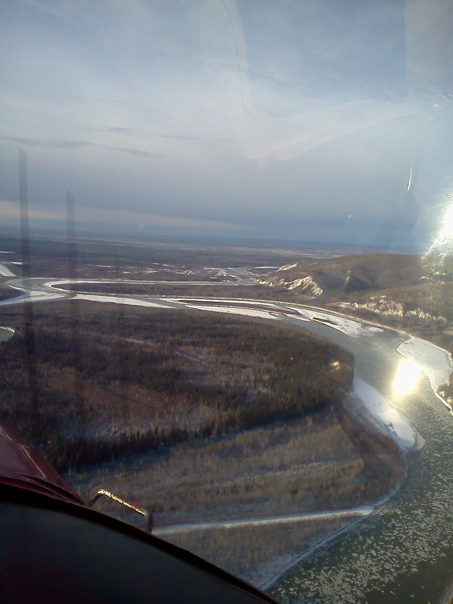
Here is Nenana. The town is on the right of the picture, just beyond the ridge. The runway is all the way on the left. In driving through Nenana, I always thought the airstrip was way closer to all the buildings.
Nenana, Alaska. The ice in the river (bottom right) is really cool looking.Nenana Airport, straight ahead. I didn’t realize there were 3 runways before today. Only 1 on the sectional chart…
This was my first landing at an uncontrolled airport and I definitely forgot to self announce my base and final legs. I believe ASOS reported a 14 knot crosswind, gusting to 20? This touch-and-go was somewhat terrifying. I forgot that you turn the ailerons all the way into the wind as the main wheels touch. Thank goodness for the competent instructor in the plane (whew, we didn’t flip).
Next stop: Minto. Minto Flats was so pretty with the hundreds of iced lakes/ponds. As we headed to the runway, I had to use the flight computer to calculate our speed, compare to the GPS values. It’s so weird to be able to take your eyes off the outside of the plane for a relatively ‘extended’ period (unlike driving a car :D).
The entire town of Minto, Alaska, ~11am. Picture taken as we left; CFI4 was suddenly reminded that I wanted pictures of my flights and took the controls to do some really wild steep turns. Fun.
Minto runway was 2 inches of packed snow on top of gravel. It was built up from ground level with a lot of gravel….but it just made the runway look like it rose up out of the ground for no reason (cool). Runway lights were pilot controlled. I tried to key it for the highest intensity, but apparently I can’t count to 7. I kept doing 9 because I lost count (so we got no lights, bleh).
The winds were initially straight down the runway, but I got a strong crosswind as I flared. Again, I forgot full ailerons as we touched down. My soft field landing attitude was way too level so CFI4 made me do it again. Same mistakes, ahh! (but slightly less severe). Both were straight, but not down the center. I again forgot to self announce base and final.
All the buildings in Minto, Alaska
On the way back, I picked an altitude of 5500ft (the highest I’ve ever piloted so far). It was high so we could clear Murphy Dome:
Murphy Dome; the weather instruments can kind of be seen in the picture.
I still can’t find Fairbanks from the air. How can I miss it? It’s right on the Tanana River, sigh. I can’t wait ’til I’m good at recognizing things from the air. 😀
Fairbanks from the northwest – city is beyond the deep brown hills in the middle of the picture.
—~—~—~—~—~—~—~—~—~—~—~—~—~—~—~—~—~—
Things to work on:
Correct trim. I’ve noticed that the 150 is touchier to correctly trim when compared to the 152. My altitude was constantly +/- 100ft of what I wanted.
Landings: I had too much power in as I flared all 4 times; used up too much runway. My last landing was so pretty until I forgot to pull the power to idle (still ballooning too).
Remember to self announce all pattern legs at uncontrolled airports
We finally have snow in Fairbanks – it held off til about noon yesterday and then it was fluffy white stuff all day. Too bad it didn’t wait until midnight (if it had, it would have been the second Fairbanks Halloween without snow on the ground – second one since anyone had been keeping records).
—~—~—~—~—~—~—~—~—~—~—~—~—~—~—~—~—~—
The morning was marginal VFR but lifting quickly. I didn’t take a picture but it was really strange to have the low fog/cloud cover the mountains by west ramp – yet east ramp (general aviation) was nice and clear. I was my choice of whether I wanted to do more soft field work (now I definitely need it for the snow covered Alaskan runways) or start cross-country work. I didn’t love the idea of soft field work, but after last lesson, and all the non-straight landings, I wanted to perfect my technique.
I had scheduled today’s lesson a week ago in the 152. It’s not my normal plane (the 150 is my usual pick because it’s easier for me to do maneuvers like stalls) – but someone else beat me to it – and as of last week, I thought I would still be working on normal pre-solo landings – where the plane choice doesn’t matter. I suppose that’s where doing landings was better than a cross country because I didn’t want to add the new flying elements to the unfamiliar instruments of the 152.
152 ready for its next victim after me. Engine blanket only partially velcroed on so it doesn’t get dirty from dripping oil.
Taxiing: um, where are my lines? They’re completely obscured now and will be until April. It was kinda of a relief to not worry about staying on the line but unnerving because my only references (buildings and parked planes) were all really far from the taxiway. I need needneed to remember that you never taxi over the sewer grates (my taxi lines helped me avoid them….but now they’re gone…).
[grate picture via google]
As the snow continues to build up this winter, the grate will probably usually remain open – but there may be a 6 inch drop from snow packed surface to grate. Taking out the propeller would be a really stupid mistake.
The runways were perfectly clear of snow – awesome. Alaska ‘road’ crews do such a nice job – I wish they’d get the taxiways.
Got 4 soft field landings on 20L (good to practice the left base landings); then CFI2 said to go home because he wasn’t going to waste my money making me practice something I already know (funny story – he actually made the full stop radio call to tower but I didn’t see him press anything….so I repeated the exact same thing on the radio. Sorry tower 😉 ). Nice praise but it always makes me nervous when he says that (‘what is he going to say when I mess this up next time’).
Soft field takeoff – I need to work on pitching to level and accelerating in ground effect before climbing. I know I need to be closer to the runway, but it is so strange not to immediately climb.
Other than flaring slightly too early 3/4 times, ballooning once, the landings were straight, soft, and on centerline. Centerline was a nice unexpected bonus for me, yay! Has it finally clicked like everyone said it would? Hope so 😀
I believe the test trucks were on the runway (testing stopping distance) on one of my downwind legs. ATC told me to do a right 360° turn as I was abeam the end of the runway. That was weird. I didn’t concentrate hard enough on wind correction and ended up drifting the tiniest bit east from the airport (it wasn’t very noticeable so maybe the instructors are right, I’m much too hard on myself).
Taxi to parking – soft field because of the snow – My arm actually started cramping up from holding the yoke all the way back (really need to hit the gym).
—~—~—~—~—~—~—~—~—~—~—~—~—~—~—~—~—~—
No sectional charts available for purchase (anywhere in town) because the new ones come out soon (end of next week?). Is this just a Fairbanks thing? All the old ones have walked away from the flight school so learning to plan the cross country this weekend will be interesting.
![Flight route: PAFA-PAML-PACL-PAFA [skyvector.com graphic]](https://flyinginfairbanks.files.wordpress.com/2013/11/screenshot-2013-11-07-23-12-17.png)


![route: PAFA-PAUN [skyvector.com graphic]](https://flyinginfairbanks.files.wordpress.com/2013/11/screenshot-2013-11-24-21-26-051.png)


![[http://toonclips.com/design/947]](https://flyinginfairbanks.files.wordpress.com/2013/11/947.jpg?w=360&h=372)
![[http://www.wunderground.com/radar/map.asp]](https://flyinginfairbanks.files.wordpress.com/2013/11/screenshot-2013-11-21-23-55-44.png?w=604&h=422)
![Fairbanks Temperature Inversion is visible. Power plant output rises only slightly before leveling off and returning to the ground. [http://seagrant.uaf.edu/news/01ASJ/12.14.01bad-air.html]](https://flyinginfairbanks.files.wordpress.com/2013/11/smokestackfaitempinversion.jpg?w=300&h=264)

![[Courtesy B. Wu]](https://flyinginfairbanks.files.wordpress.com/2013/11/1476167_10151798401637058_833566936_n.jpg)


![Picture of ALSF (to a pilot, the white ball of light will move towards the runway) [http://www.flyplatinum.com/blog/?p=492]](https://flyinginfairbanks.files.wordpress.com/2013/11/alsfii1.jpg?w=483&h=318)